McCoin Lower Tree 86: Difference between revisions
From Heritage Apple Corps
Bot: Add diam_height, Historical Reference from TSV |
Bot: Add semantic coordinate properties |
||
| Line 32: | Line 32: | ||
== Location == | == Location == | ||
[[Has latitude::44.429584]] | |||
[[Has longitude::-121.087588]] | |||
{{#display_map: 44.429584,-121.087588 }} | {{#display_map: 44.429584,-121.087588 }} | ||
Revision as of 15:48, 2 February 2026
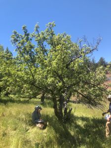
| Tree #86 | |
|---|---|
| Field Tag | 86 |
| Orchard | McCoin Lower |
| Species | Apple |
| Variety | [[Has variety::Unique]] |
| DNA ID (2024) | Unique |
| Condition | fair |
| Height | 16 ft |
| Diameter | 10 in |
| Diam. Measured At | 12 in |
| Crown Width | 15 ft |
| Live Crown | 80% |
| DNA Code | AFRS-066 |
Photos
-
 Tree #86

Description
Possible crabapple. Two trees appear joined below ground level, some crown dead. Very bitter small red apples. Thought to be planted as an intentional cider tree.
Assessment
- Inspected: 03/15/24 00:00:00
- Inspectors: CJ, CS, AO
Visual Identification
Originally identified as: very bitter small red, cider tree?
Location
44.429584 -121.087588
Remarks
- Historical Reference: 18

