McCoin Lower Tree 72: Difference between revisions
From Heritage Apple Corps
Bot: Add geographic coordinate property for maps |
No edit summary |
||
| Line 33: | Line 33: | ||
== Location == | == Location == | ||
[[Has latitude::44.429402]] | [[Has latitude::44.429402]] | ||
[[Has longitude::-121. | [[Has longitude::-121.029402]] | ||
[[Has coordinates::44.429402,-121. | [[Has coordinates::44.429402,-121.029402]] | ||
{{#display_map: 44.429402,-121. | {{#display_map: 44.429402,-121.029402 }} | ||
== Remarks == | == Remarks == | ||
Revision as of 16:49, 2 February 2026
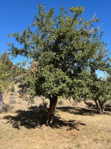
| Tree #72 | |
|---|---|
| Field Tag | 72 |
| Orchard | McCoin Lower |
| Species | Apple |
| Variety | Missouri Pippin |
| DNA ID (2024) | Missouri Pippin |
| Condition | good |
| Height | 24 ft |
| Diameter | 13 in |
| Diam. Measured At | 24 in |
| Crown Width | 18 ft |
| Live Crown | 80% |
| DNA Code | AFRS-079 |
Photos
-
 Tree #72

Description
Twin trunks, nice full crown.
Assessment
- Inspected: 03/15/24 00:00:00
- Inspectors: CJ, CS, AO
Visual Identification
Originally identified as: Collins
Location
44.429402 -121.029402 44° 25' 45.85" N, 121° 1' 45.85" W
Remarks
- Historical Reference: 5

